Background
Over the course of the 21st century, climate change is projected to cause major changes in hydrology across Washington. Scientists have already detected negative trends in glacier volume and snowpack (Granshaw and Fountain 2006, Sitts et al. 2010, Stoelinga et al. 2010) and in earlier peak streamflow in many rivers (Stewart et al. 2005). These trends are expected to continue in the future, along with increasing flood magnitudes and declining summer minimum flows (Elsner et al. 2010, Mantua et al. 2010). Climate change is projected to be most pronounced at middle elevations, where a substantial proportion of each drainage basin is located near snowline (i.e., the “mixed rain and snow” zone). In these watersheds, warming will cause more precipitation to fall as rain instead of snow, which will decrease snow accumulation, hasten melt, and increase runoff (Hamlet et al. 2007).
Hydrological projections for the mid to late 21st century show a shift in flood frequencies that results in larger peak flows at all recurrence intervals, e.g., 2-year, 5-year, 10 year, etc. (Salathè et al. 2014). Changes in stream flow are expected to alter sediment transport and channel morphology, however, published research analyzing the potential impact of future climate change on fluvial processes is lacking. As previously noted, in much of Washington State, climate change is expected to increase the proportion of precipitation that falls as rain rather than snow, leading to larger winter peak flows and wider channels (Figure 1). Significant increases in channel width relative to culvert width could create barriers or impediments to fish passage at culverts.
WDFW has published water crossing design guidelines (i.e., Barnard et al. 2013) that are used by state and local governments throughout the United States (NAACC 2016, USACE 2016). WDFW is nationally recognized as the inventor of the stream simulation culvert design (Cenderelli et al. 2011), which is based on a geomorphic approach to culvert design. A geomorphic culvert design seeks to maintain continuity of channel structure and composition by conveying water, sediment, and wood in the same way as the surrounding stream reach (Barnard et al 2013, Cenderelli et al. 2011). WDFW believes that a geomorphic approach is the best way to enable upstream and downstream movements of fish and other stream-associated species through culverts (Barnard et al 2013).
This website was motivated by a need to address potential adverse impacts to fish populations due to climate change. Specifically, in Washington State, climate change could indirectly create barriers to fish movement at culverts and a consequent loss of fish habitats. Incorporating projections of future bankfull width and/or 100-year flood discharge into culvert design could prevent, or at least reduce, negative impacts due to climate change.
This website provides projections for the design of only culverts and other hydraulic structures located in streams with a bankfull width of roughly 20 ft wide or less. Projections of future percent change in bankfull width and 100-year flood for a culvert’s location are simply the projections for the grid cell in which the culvert is located. We believe this approximation is satisfactory because the drainage area of most streams of that size are smaller than the size of one grid cell, and the difference between the percent changes of adjacent grid cells typically is rather small.
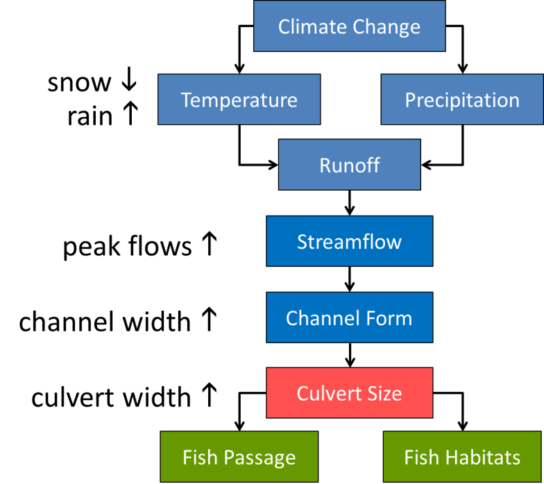
Figure 1. A conceptual model of important causal relationships between culverts and climate change. Climate change is projected to increase the proportion of precipitation that falls as rain rather than as snow. As a result, winter peak flows in western Washington are expected to increase in volume. Increased peaks flows are known to alter channel morphology. Wider channels require wider culverts.
Help
Click on the help button for instructions on how to generate projections for your culvert site. Or, contact George Wilhere at 360-902-2369, George.Wilhere@dfw.wa.gov.
Download options
This website can generate two types of output: 1) a 1-page report in a PDF file, and 2) a comma-delimited text file containing future projections for multiple culverts. The text file output is enabled when a shapefile containing culvert locations is uploaded.
Both types of output provide means for percent change in future bankfull flow, future bankfull width, and future 100-year flood discharge. These projections are those for the grid cell in which the culvert is located, and they are provided for two future time periods: the 2040s (2030-2059) and 2080s (2070-2099). The mean values are the average of 10 projections based on 10 separate global climate models (GCMs). The report presents the 10 projections in two graphs, one for bankfull flow and one for 100-year flood, and the text file provides the numbers used to make the graph.
The main purpose of the two graphs is to convey uncertainty associated with the projections. Black dots on the graphs correspond to each of the 10 separate climate change projections for the 2080s time period. The wider the spread of dots, the greater the uncertainty. The red line, blue line, and green box are the mean, median, and inter-quartile range, respectively. Hovering the cursor over a black dot will reveal the GCM name and the projection’s value, and hovering over the green box will display other statistics.
Disclaimer
The Washington Department of Fish and Wildlife makes no guarantee concerning the data's content, accuracy, or completeness. WDFW makes no warranty of fitness for any purpose other than culvert design and assumes no liability for the data represented here.
References
Barnard, R.J., J. Johnson, P. Brooks, K.M. Bates, B. Heiner, J.P. Klavas, D.C. Ponder, P.D. Smith, and P.D. Powers. 2013. Water Crossings Design Guidelines. Washington Department of Fish and Wildlife, Olympia, WA.
Cenderelli, D., K. Clarkin, R. Gubernick and M. Weinhold. 2011. Stream simulation for aquatic
organism passage at road-stream crossings. Transportation Research Record: Journal of the Transportation Research Board 2203:36-45.
Elsner, M.M., L. Cuo, N. Voisin, J.S. Deems , A.F. Hamlet , J.A. Vano , K.E.B. Mickelson , S.Y. Lee, D.P. Lettenmaier. 2010. Implications of 21st century climate change for the hydrology of Washington State. Climatic Change 102:225–260.
Granshaw, F.D., and A.G. Fountain. 2006. Glacier change (1958–1998) in the North Cascades
National Park Complex, Washington, USA. Journal of Glaciology 52:251−256.
Hamlet, A. F., P.W. Mote, M.P. Clark and D.P. Lettenmaier. 2007. Twentieth-century trends in runoff, evapotranspiration, and soil moisture in the western United States. Journal of Climate 20:1468-1486.
Mantua, N., I. Tohver and A. Hamlet. 2010. Climate change impacts on streamflow extremes and summertime stream temperature and their possible consequences for freshwater salmon habitat in Washington State. Climatic Change 102:187-223.
NAACC. 2016. Implementing Codes and Standards. North Atlantic Landscape Conservation Cooperative, University of Massachusetts, Amherst, MA. accessed at https://streamcontinuity.org/resources/crossings_toolkit/impl_codes_standards.htm.
Salathé Jr., E.P., A.F. Hamlet, C.F. Mass, S.-Y. Lee, M. Stumbaugh, and R. Steed. 2014. Estimates of twenty-first-century flood risk in the Pacific Northwest based on regional climate model simulations. Journal of Hydrometeorology 15: 1881-1899.
Sitts D., A.G. Fountain, and M. Hoffman. 2010. Twentieth century glacier change on Mount Adams, Washington, USA. Northwest Science 84:378–385.
Stewart, I.T., D.R. Cayan, and M.D. Dettinger. 2005. Changes toward earlier streamflow timing across western North America. Journal of Climate 18:1136-1155.
Stoelinga, M.T., M.D. Albright, and C. F.Mass. 2010. A new look at snowpack trends in the Cascade Mountains. Journal of Climate 23:2473-2491.
USACE. 2016. Special public notice: nationwide permit reissuance request for comments. U.S. Army Corps of Engineers, Seattle District, WA.
Wilhere, G.F., J.B. Atha, T. Quinn, I. Tohver, and L. Helbrecht. 2017a. Incorporating Climate Change into the Design of Water Crossing Structures. Habitat Program, Washington Department of Fish and Wildlife, Olympia, WA. https://wdfw.wa.gov/publications/01867
Wilhere, G.F., J.B. Atha, T. Quinn, I. Tohver, and L. Helbrecht. 2017b. Incorporating climate change into culvert design in Washington State, USA. Ecological Engineering 104:67–79.
July 2023